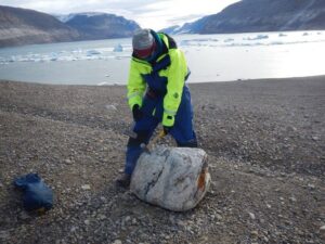
I investigate paleoclimate, with the goal of informing predictions of ice sheet fluctuations and sea level rise. My past work for both my undergraduate1 and Masters2 research used cosmogenic radionuclide exposure dating to constrain the timing of glacial retreat. This technique measures the amount of the isotope beryllium-10 (Be10) that has accumulated in boulders since they melted out of a glacier as it retreats. These boulders act as breadcrumbs that indicate where the ice once was and when the ice left. The more Be10 present, the longer it has been since that boulder was abandoned.
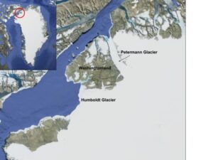
In order to enhance existing ice models of the Greenland Ice Sheet (GIS), further research is needed into the dynamic nature of the ice sheet and its sensitivity to atmospheric and oceanic changes. We went to northwestern Greenland to find out how Petermann Glacier had reacted to climate changes since the last Ice Age (see map). Petermann Glacier alone is responsible for draining 6% of the modern GIS3, so its history is vital to future predictions of deglaciation. We spent 6 weeks – much of which was travel time – collecting rock samples deposited by the glacier. Check out more about the entire research expedition here.
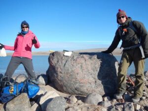
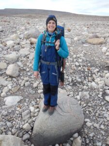
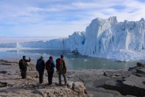
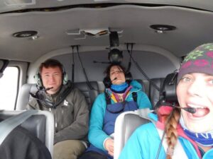
We flew first to New York, then southern Greenland, then the American Air Force Base at Thulle. We then boarded a Swedish icebreaker ship (The Oden) to take us up Nares Strait and to Petermann. The landscape was so vast that we used a helicopter to collect samples and spent most days away from our camp alongside the glacier. We used electric fencing and rifles as protection against polar bears, and only saw one (luckily far away from camp!). Hiking along Petermann we saw moraines (hills of sediment and rock left by retreating ice), glacially polished bedrock, and – one day – a large flood.
Once back at UW-Madison we went into the lab and over a few months isolated the beryllium present in each sample. This was then sent to the PRIME Lab at Purdue University to measure the ratio of Be10/Be9. Once we knew this ratio, we applied accumulation curves to interpret an exposure age. The more Be10 is present, the longer the exposure. We then plotted these samples on a map, and could see where the ice used to be, and when.
What we observed were moraines at both Petermann and the adjacent Humboldt glacier with exposure ages that averaged about 300 years, and are interpreted as Little Ice Age features. The Little Ice Age was ~400 year-long atmospheric cooling observed throughout the northern hemisphere, and here we see that these far-north glaciers had a similar response to those at lower latitudes. We also had a few exposure ages that suggested the possibility of retreat around ~2 thousand years ago (ka) ; while we do not have enough data to conclude anything, this might point to a Neoglacial advance (a phenomenon observed in southern Greenland4 and neighboring Svalbard1.
At Humboldt glacier, we also sampled a moraine farther out from the ice margin. This moraine had exposure ages that averaged about 8.3 ka. This has two major implications:
- The deglaciation of Washingtonland and the opening of Nares Strait (see map) occurred before 8.3 ka.
- Humboldt glacier stabilized or readvanced following deglaciation, then abandoned this moraine around 8.3 ka.
The first finding agrees with radiocarbon ages and sediment cores from within Nares Strait. This was further confirmed by Dr. Liz Ceperley’s work that indicated deglaciation at around 8.5 ka5. The timing of the second event is in line with other findings along the west coast of Greenland; there is a recognized cooling event at ~8.3 ka and at ~9.2 ka related to outburst flooding from North America that slowed down ocean circulation in the North Atlantic and temporarily cooler atmospheric temperatures6.
Overall, what we learned from this work was that these high-latitude glaciers are capable of responding to abrupt changes in atmospheric temperatures on the centennial scale (hundreds of years!). This sensitivity is something to be considered in future models of the response of the GIS to future warming. I am currently starting my PhD, most likely investigating paleoclimate during the penultimate Ice Age and the Last Interglacial using the geochemistry of cave deposits.
I love chatting with people about climate, Arctic field work, grad school, science outreach, and having a family while navigating all of it. Feel free to contact me! reusche@wisc.edu
- Reusche, M. et al. 10Be surface exposure ages on the late-Pleistocene and Holocene history of Linnébreen on Svalbard. Quaternary Science Reviews 89, 5–12 (2014). http://dx.doi.org/10.1016/j.quascirev.2014.01.017
- Reusche, M. M. et al. Early to late Holocene surface exposure ages from two marine-terminating outlet glaciers in northwest Greenland. Geophysical Research Letters 45, 7028–7039 (2018). https://doi.org/10.1029/2018GL078266
- Rignot, E., Koppes, M. & Velicogna, I. Rapid submarine melting of the calving faces of West Greenland glaciers. Nature Geoscience 3, 187–191 (2010). https://doi.org/10.1038/ngeo765
- Winsor, K., Carlson, A. E. & Rood, D. H. 10Be dating of the Narsarsuaq moraine in southernmost Greenland: evidence for a late-Holocene ice advance exceeding the Little Ice Age maximum. Quaternary Science Reviews 98, 135–143 (2014). https://doi.org/10.1016/j.quascirev.2014.04.026
- Ceperley, E. G. et al. Widespread early Holocene deglaciation, Washington Land, northwest Greenland. Quaternary Science Reviews 231, 106181 (2020). https://doi.org/10.1016/j.quascirev.2020.106181
- Young, N. E. et al. Age of the Fjord Stade moraines in the Disko Bugt region, western Greenland, and the 9.3 and 8.2 ka cooling events. Quaternary Science Reviews 60, 76–90 (2013). https://doi.org/10.1016/j.quascirev.2012.09.028